Chuya River
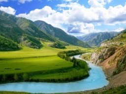
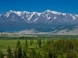
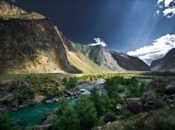
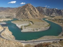
River Chuya originates in the high swampy area on western slopes of ridge Chikhachev and northern slopes of ridge Saylyugem, combining into a single channel in Chuya steppe. Length of the Chuya is more than 280 km and river basin is at least 11 000 km2. Transparent river flows out Chui steppe and confluences left tributary a dull white Chaganuzun. The water turns to unusual leaden color and seems thick. River Aktru and River Maashei, also originated from glaciers, flow in Chuya in the area of Kurai. There are several variants of etymology of the word “Chuya”. The most realistic and reasonable is the origin the name “Chuya” from Turkic "Chuu", which means "water", because indigenous people called the confluence of Chuya and Katun just “Chuu”, identifying this area with the canonical representations of water elements until the 19th century. Chuya flows in the low banks, overgrown by bushes and sea buckthorn, from the village of Kosh-Agach to the confluence with River Chagan-Uzun. Then the river suddenly changes its character: it becomes full-flowing, increasing the flow level, the banks become narrow. Almost continuously rapids and shoals appear one after another during 45 km to the bridge leading to the alpine camp Aktru and Aktru glacier. Average slope is 4.6 meters in one kilometer. Chuisky tract lies along the River. This section of the river is known as Mountain Chuya. It enters the Kurai steppe in the area of Kurai village and becomes divided into channels again. After the level 457 km where Chuya hydroelectric station is located, River begins to grow turbulent and swift. Mazhoysky cascade is the hardest part of the water routes which lied down below. Chuya, leaving a wide valley, cut narrow gorge in cliffs. Mazhoysky is a 20-kilometer gloomy gorge with a snow at the top of cliffs. Lower part goes into the canyon with steep walls with heights of 100 - 150 meters. Powerful stream of Chuya roars, forcing its way through stones, foaming up to 4 meters and falling into waterfalls. River Chuya flows in a wide valley with terraces below. Numerous boulders and chunks jut out rushing foaming water. A dull color of Chuya flowing into Katun River changes its color a lot. Altaians consider, place where Chuya confluences with Katun is sacred, water spirits of Altai inhabit this place according to legends. Here was an ancient sanctuary was in Scythian period, as shown by petroglyphs in the form of a divine on rocks. Elevated deck located on a hill allows to watch breathtaking view of connection of two great rivers and their further course in the same way. But still far downstream the border or rivers is visible: dull white Chuya and emerald Katun flow for some time without mixing in one channel, but each on its side. Chuya River Valley is a picturesque hollow, surrounded by alpine meadows, steppes, with islands of coniferous forests and ridges. Convenient location, abundance of natural resources, mild climate and proximity of fresh water are reasons why ancient people and the nomadic tribes settled here. They left behind many traces such as an ancient burial mounds, petroglyphs and other archaeological sites. One of the most famous places is the Kalbyk-Tash, known for its rock paintings belonging to different chronological periods from the Neolithic to the ancient Turkic period. Currently settlements Kurai, Aktas and Kosh-Agach are located in Chuya River area. Speaking of Chuya River, it is impossible not to mention a well-known federal highway M-52 "Chuiski" tract, cutting the rock along the river. The history of "Chui tract" goes back to thousands of years ago, when ancient Silk Road lied these places where caravans with goods from China have followed. The remains of the old path, lined with cobblestone are saved just above the road in the area of the White Bohm. Wilderness nature, combining mountains and the Siberian taiga, the proximity of peaks and glaciers attract more and more tourists to the area. |