Kronstadt
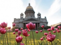
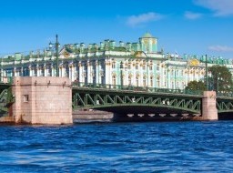
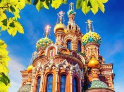
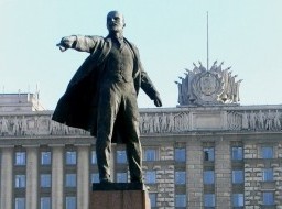
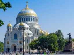
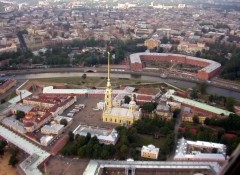
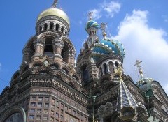
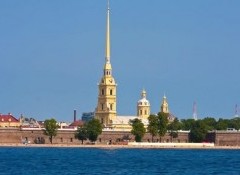
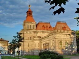
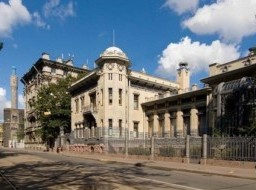
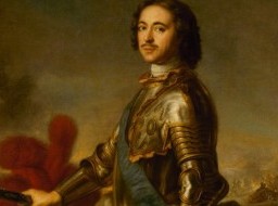
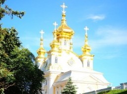
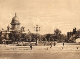
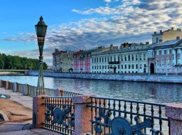
Kronstadt was founded by Emperor Peter the Great in 1704 as a maritime fortress and naval base on Kotlin Island. The name "Kronstadt" was invented by Peter the Great, and in German means "Crown City".The port is ice-bound for 140–160 days in the year, from the beginning of December to April. A very large proportion of the inhabitants are sailors. The Kronstadt Sea Fortress used to be considered the most fortified port in the world. Kronstadt still retains some of the "forts", small fortified artificial islands. Others were destroyed or recycled during the construction of the Saint Petersburg Flood Prevention Facility Complex, a brand new dam of protective structures, which connects the island to the shore and is part of the federal city's Ring Road. Formerly, there were 42 such forts, situated in line between the southern and northern shores of the Gulf of Finland. Some fortifications were located inside the city itself, and one was on the western shore of the Kronslot Island (on the other side of the main navigational channel). Until 1998, Kronstadt was a closed city, from then on it became a touristic attraction with free access to its territory. The exception is Kronstadt military harbour and the territories of various military units stationed in the city and surrounding area. The architecture of the city centre and city walls mostly dates from the first half of the 19th century. Kronstadt Located on a narrow isle in the Gulf of Finland, the city of Kronstadt has been watching over the approaches to St. Petersburg since its founding in 1703. Kronstadt is a city located on Kotlin Island in the Gulf of Finland. In 1703, on the southern part of the island, Peter the Great ordered the construction of a fort to protect the approaches to St. Petersburg from the Swedish navy. The foundations of the fort were built during the winter, and used ingenious techniques. They built small wooden cabins right on top of the ice that covered the bay, and then filled them with heavy boulders. Under their own weight, these constructions sank to the bottom. Thus was laid the foundation of the first building of the Kronstadt, the Kronshlot Fort. This fortress was completed by May 1704. The Swedes, sailing by at the opening of the navigation season, were more than a little surprised to see this new island, which seemed to have appeared from nowhere.After Kronshlot, the city was actively built up and developed. Peter the Great at one time even considered moving the capital of Russia to Kotlin Island, proof of the sovereign’s great affinity with water. Kronstadt, in many respects is similar to St. Petersburg; here we find the same rigorous grid of streets, also being dominated by classic buildings. Nevertheless, many things in this city are found only in Kronstadt. Kronstadt is strikingly different from other suburbs of St. Petersburg. Peterhof, Pushkin, Pavlovsk, and Gatchina were built as places of recreation and entertainment for the royal family. Kronstadt, on the contrary, was built “for serious business”. For a long time, the city was the main military base of the Baltic Fleet, and sailors and their families still make up a significant part of the population of Kronstadt. Warships continue to moor at the city’s wharves, and the city is still dominated by the spirit of a military camp. A trip to Kronstadt is a perfect getaway for those who have had their fill of Petersburg’s most celebrated landmarks. The fresh sea air, unpretentious architecture and romantic forts are a world away from the brightness of the Peterhof fountains, the colorful mosaics of the Church of the Savior on Blood and the shine of the brand new Amber Room. Main sights The town of Kronstadt is built on level ground and is thus exposed to flooding, most notably in 1824. On the south side of the town there are three harbors: the large western or merchant harbor, the western flank of which is formed by a great mole joining the fortifications which traverse the breadth of the island on this side; the middle harbor, used chiefly for fitting out and repairing vessels; and the eastern or war harbor for vessels of the Russian Navy. The Peter and Catherine Canals, connecting with the merchant and middle harbours, traverse the town. Between them stood the old Italian palace of Prince Menshikov, the site of which was later occupied by a pilot school. In the second half of the 18th century the building of former Italian palace began to be used for various military training institutions. In 1771–1798 the Sea Cadet Corps were housed here. The Cadet Corps was transferred to St Petersburg and from 1798 to 1872 the Navigating School was situated in the former palace. Near with the former Italian palace the Kronstadt sea-gauge is situated. Sea level observations began in Saint Petersburg in 1703. On Kotlin Island, with main naval fortress of the Russian Empire, it began in 1707. This monitoring was necessary because level of the Finnish Gulf could change considerably in a short time, creating problems for shipping. The annual flood also required close monitoring of the water level. The Kronstadt sea-gauge with the tide gauge pavilion is the zero level of the Baltic system of depths and heights. All depths and altitudes (even the heights of spacecraft) in Russia and some other countries (former Russian Empire) are measured from the level of Kronstadt sea gauge. Yuri Gagarin, the first man in space, ironically said in 1967 that this is it the Hub of the Universe. The modern town's most striking landmark is the enormous Naval Cathedral, built from 1908 to 1913 and considered to represent a culmination of Russian Neo-Byzantine architecture. The older St Andrew Cathedral(1817), formerly Kronstadt's pride and beauty, was destroyed on Communist orders in 1932. St John of Kronstadt, one of the most venerated Russian saints, served there as a priest from 1855 to 1908. Among other public buildings are the Naval Hospital, the British Seamen's Hospital (established in 1867), the Civic Hospital, the Admiralty (founded 1785), the arsenal, dockyards and foundries, the School of Marine Engineering, and the English Church. The port is ice-bound for 140–160 days in the year, from the beginning of December to April. A very large proportion of the inhabitants are sailors. The Kronstadt Sea Fortress was considered the most fortified port in the world. Kronstadt still retains some of the "forts", small fortified artificial islands. Formerly, there were 22 such forts, situated in line between the southern and northern shores of the Gulf of Finland. Some fortifications were located inside the city itself and one was on the western shore of the Kronslot Island (on the other side of the main navigational channel). Nowadays, the construction of the Saint Petersburg Dam has led to some of the forts being demolished. The dam also permitted Kronstadt and some of the forts to be reached without using a boat. Among the most important surviving forts are Fort Konstantin, the biggest in the Gulf of Finland; Fort Rif on the western shore of the island; and the particularly well-preserved Fort Alexander I (Plague Fort). The largest and the newest of the forts, built at the beginning of the 20th century, is Fort Totleben, named after Eduard Totleben. |
|